
Limerick's spatial data can be accessed as WMS and WFS services, directly as a PostGIS database connection, or as downloaded flat files.
WMS and WFS services can be consumed using a variety of coordinate systems.
WMS and WFS services are encrypted using Limerick's SSL certificate.
WMS
https://geoserver.limerick.ie:8080/geoserver/gwc/service/wms?tiled=true
WFS
https://geoserver.limerick.ie:8080/geoserver/gwc/service/wfs?tiled=true
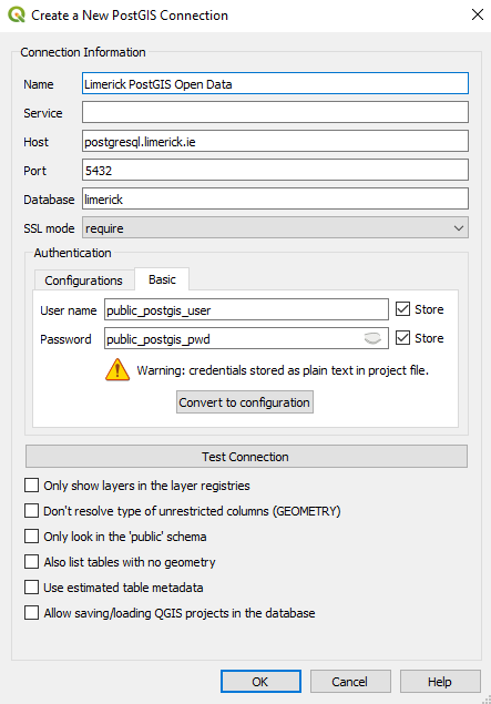
Spatial data can be accessed directly from the database using GIS software such as QGIS, database UI software such as pgAdmin, a map server such as GeoServer, custom scripts, or any other method you wish.
Connections must be encrypted or they will be refused.

CSV
https://geoserver.limerick.ie:8080/geoserver/wfs?service=WFS&version=2.0.0&request=GetFeature&typeNames=Limerick:amenities&srsname=EPSG:2157&outputFormat=csv
GeoPackage
https://geoserver.limerick.ie:8080/geoserver/wfs?service=WFS&version=2.0.0&request=GetFeature&typeNames=Limerick:amenities&srsname=EPSG:2157&outputFormat=geopackage
GML
https://geoserver.limerick.ie:8080/geoserver/wfs?service=WFS&version=2.0.0&request=GetFeature&typeNames=Limerick:amenities&srsname=EPSG:2157&outputFormat=gml3
JSON
https://geoserver.limerick.ie:8080/geoserver/wfs?service=WFS&version=2.0.0&request=GetFeature&typeNames=Limerick:amenities&srsname=EPSG:2157&outputFormat=application/json